Projects: Technology on the Trail Undergraduate Capstone Spring 2018

The Spring 2018 school term provided the opportunity for senior undergraduate students in computer science to take part in client-based projects related to technology on the trail. Each project was asked to address some trail-related problem through a tech implementation. Below is a summary of the projects that they undertook.

NOTE: some of the students continued their work on the projects, and others were continued by grad students and clients toward being incorporated in grants, papers, theses, and dissertations. This post has been and will continue to be updated with links to new papers.

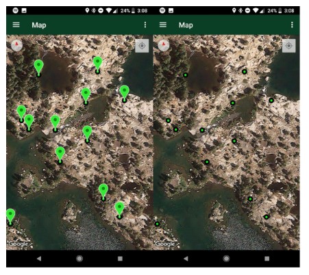
  • GreenSites: Navigating Towards Sustainable Camping. Undergrads Michael D’Avella, Forrest Doss, and Matthew Scanland undertook a project sponsored by Jeff Marion and his grad students in Virginia Tech’s Department of Forest Resources and Environmental Conservation. They were tasked with creating a mobile hiking application that would allow users to be able to navigate towards sustainable campsites and avoid areas that are detrimental to the environment. Their app allowed conservationists to map existing and potential campsites to help determine sites with the potential to be the most environmentally friendly. (See image below.)
  • TrailBuddy. Rui Jin and Shumeng Zhang crafted an app to identify tagging approaches for photos taken on the trail during hikes and other outdoor activities—at times when people do not wish to manage their photos but do wish to capture context. Grad student Derek Haqq is continuing this research as part of his Ph.D.
  • The Gardenator: Fostering Learning by Improving Attitudes towards Science. Undergrads Anne Hoang, Havisha Panda, and Jennifer Shenk crafted a scavenger hunt app in support of the Pollinator Garden at the Science Museum of Western Virginia (SMWV). They sought to improve user-user and user-exhibit interactivity by improving attitudes toward science and learning. The project was sponsored by ICAT’s Outreach and Engagement Coordinator Phyllis Newbill, along with staff at the SMWV. Grad student Lindah Kotut is seeking to publish continued work on this project in support of her Ph.D. dissertation. (See image below.)
  • Safe Drinking Water with Smart Technology. Undergrads Arianna Krinos and Priyanka Kogta, together with grad student Jingoo Han, developed a web site and Java app to increase understanding of new smart and connected technology for drinking water systems. The project breaks down barriers of understanding to increase public confidence in the quality of drinking water.
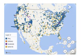
  • Twitter Tweet Visualization on Trails. Undergrads Mark Episcopo, Vedant Tyagi, Patricio Moreno, and Shivani Rajasekaran crafted a visualization showing tweet locations using Apache Spark and Scala. They looked for interesting themes in over 1.5 million tweets by trail users around the world. (See image below of tweets filtered by season.)
  • Poison Ivy Tracking App for ITCHY. Undergrads James Wilson, Gunnar Arnesen, Douglas Botello, and Jason Merewitz worked with Plant Pathology, Physiology, and Weed Science professor John Jelesko on an app for tracking locations of poison ivy. This project is part of Dr. Jelesko’s ITCHY project (nvestigating Toxicodendron and Habitats for Years) that studies the times and locations that poison ivy can be found. The work supports citizen scientists in their efforts to help this scientific endeavor. Computer science grad student Tim Stelter is continuing this work.
  • Tracking Birds in the New River Valley. Undergrads Zijian Xu and Hongyi Zhen created Birding Buddy, a digital education mobile app to get young people excited about bird watching. It includes a field e-notebook to help users record bird observation date, time, location, photos, audio, and more. It includes a wiki with the 28 most common birds in our region. Birding Buddy supports the Boy Scout Bird Study Merit Badge requirements 5 and 6. Grad student Tim Stelter is continuing this work (along with other projects above) as part of his citizen science research.
GreenSites screenshots showing potential sites and surrounding terrain. Scientist can easily create markers indicating potential sites, then study the resulting map to identify promising sites at a later time.
Participants using the Gardenator application in-situ and during a showcase, together with the available options for interaction. The user selects a category, and using the clue given takes a picture. The application then applies image recognition to check for correctness, then revealing a successful page or a failed page accordingly
This tweet visualization shows hiking by seasons, with winter hiking largely (but not exclusively!) happening in the warmer regions of North America.

Navya Kondur thesis recap: Using K-Mode Clustering to Identify Personas

Navya Kondur successfully defended her thesis titled Using K-Mode Clustering to Identify Personas for Technology on the Trail on April 19, 2018.  Navya wasn’t originally thinking to do a thesis when she started examining some of the questionnaire results from Gracie Fields’ thesis, but Navya identified some interesting questions within Gracie’s data sets and, most importantly, a new way to examine the data.

Navya presented some preliminary results at the GROUP 2018 workshop, receiving some great feedback from Mike Jones, who has been working on some similar persona creation activities. Navya’s background in statistics served her well in highlighting some possible ways to analyze results from some of Gracie’s data sets; specifically, by using k-mode clustering to identify groups of like-minded hikers.

K-mode clustering is a method to identify clusters within categorical data.  It is a modification of the more popular k-means analysis, adapted for use with categorical data such as types of gear that people bring on hikes, sleeping preferences when on multi-day hikes, and selections between paired “would-you-rather” options (as featured in Gracie’s thesis work).  Navya administered a series of “would-you-rather” questionnaires at various Tech on the Trail events, collecting sufficient data to craft clusters.  Since the clusters are not particularly descriptive or evocative, Navya then crafted five personas that helped to reflect some of the differences among hikers; e.g., younger people embrace technology but lack the money for it.

Navya’s thesis really helped to highlight the possibilities in her line of research, particularly with regard to k-mode clustering and persona identification–though the small number of participants yielded a small number of clusters.  However, her work has resulted in a funding proposal that seeks to identify the nuances between people on trails, and, if funded, we will be on track to publish a large-scale examination of this domain in the future (and maybe we can talk Navya into returning to VT for her Ph.D.)  Until then, check out details about this work in Navya’s GROUP workshop paper and (when released) thesis document.

img1524155613933
Navya and her committee (L-R: Scott, Steve, Mike) at her defense

GROUP workshop: Toward opportunity in conflict

At ACM GROUP’s Technology on the Trail Workshop, Lindah Kotut and Mike Horning led an activity on the theme “Who’s out there? What are they doing?” that morphed into “Opportunity in conflict”.  The goal of the session was to explore the people that take technology onto trails, toward looking for conflicts that arise among groups of people and the opportunity in conflict.

Participants in the workshop drew from a large set of hiker roles, looking at tensions within the groups (e.g., hunters who use advanced weapons vs those who don’t think that gives animals a fair chance) and between groups (e.g., people looking for solitude, and those looking to play music with friends).  Lindah took the lead in identifying several tensions that seemed to pop up repeatedly:

  • presence vs distraction: Many people from most of the groups seek to escape technology by heading into wilderness, but they often are drawn to use technology to check that one important message or take that one essential picture.  There’s value in these things, but it may not be worth the distraction.
  • experiential vs practical: The line between these is often blurred, such as the desire for a family to document a trail experience in photos, and the competing desire to simply enjoy the experience.
  • professional vs amateur: There was a perceived value in professional use of technology, somehow making it forgivable to use, whereas the needs of amateurs did not seem as important.
  • known vs unknown: Our group struggled with ways of knowing about professions outside of our scope, whether the uses of technology were as helpful and/or arduous as they seem.  It’s hard to understand professions related to rescue, science, and hunters without representatives from those groups in attendance.

This workshop effort represents one step in understanding who’s on the trail.  It was encouraging to make progress on opportunities, not just resolutions.  This work continues, with a next step to appear in the HCI Outdoors Workshop at the ACM CHI Conference in May 2018.

GROUP workshop: Crowds on the trail

A work session at the ACM GROUP Technology on the Trail Workshop featured the theme “Crowds on the Trail”, led by Tim Stelter.  Tim explored how citizen science efforts can be used to inspire modest and appropriate tech uses on trails and in other outdoor settings that will be minimally intrusive to those doing the work but helpful to scientists who need to collect information.

Tim started by presenting two similar examples of signage meant to inspire photo taking which have prompted very different reactions.  The “change bracket” signs encourage people to take timestamped pictures of an area of ecological interest, while the “photo frame” signs sought to provide a fun addition to a favorite viewing spot.

Both photos are shown below, with links to the articles that featured them.

One of the “Change Bracket” signs designed and deployed by the Nerds for Nature group to track recovery from wildfires and other habitat changes.  The sign and accompanying bracket encourages hikers in an area to take a picture, positioned on a post-mounted bracket, that captures an area recovering from wildfires.  Hikers post the pictures to social media, and scientists use timestamped images to track recovery over time.  Image from Dan Rademacher.

A frame was added to an overlook at the Garden of the Gods to encourage picture-taking for personal enjoyment.  Some people enjoyed the frame, but protests over the lack of input to the addition to the park and the changes caused by the sign to the view of nature resulted in its removal.  Image from KKTV, reproduced per their terms of service.

Differences in the preparation and instantiation of these signs contributed to their very different reception by visitors.  The “change bracket” group was well-integrated within the park and community, seeking guidance at every stage of integration.  Their sign clearly reflected a purpose rooted in common good, and contributions from participants are visible on social media.  The “blue frame” group did not seem to take public opinion into account, and their sign changed the nature of an established overlook.  The sign was intended for fun, with minimal societally-useful purpose.

Tim couched the discussion within the principles of the International Association for Public Participation (IAP2), which describes a spectrum of public participation that increases decision impact.  Spectrum levels include: inform, consult, involve, collaborate, and empower.  A breakdown at any level can result in a corresponding breakdown in trust and participation.  Tim led a discussion that looked at citizen science examples through the lens of this spectrum, noting that efforts like the “blue frame” group failed in the inform and involve levels.  The discussion led to a prototype ideation activity in which breakout groups designed a citizen science project and prototype that supports the levels.  Group ideas included a solar charging station that asked hikers to do a task while they were charging their devices, a flow control plan designed to discourage hiker bubbles that overcrowd shelters, and a Yelp for hikers device for identifying (and, thus, tracking) animals.

The framework proved useful, leading to discussion about its relationship to motivation of use, and of other factors that contribute to motivation.  When I discuss the change bracket project with groups, I ask for a show of hands indicating who would be willing to take part in this daily when on a hike, and generally almost every hand goes up.  I then ask who would do it hourly, and there are far fewer hands.  Motivation will have its limits, and the “asks” can’t grow too large.  Tim continues to explore these issues…input welcome!